
Van Diemen’s Land — Tasmania, Peoples and Wild Country
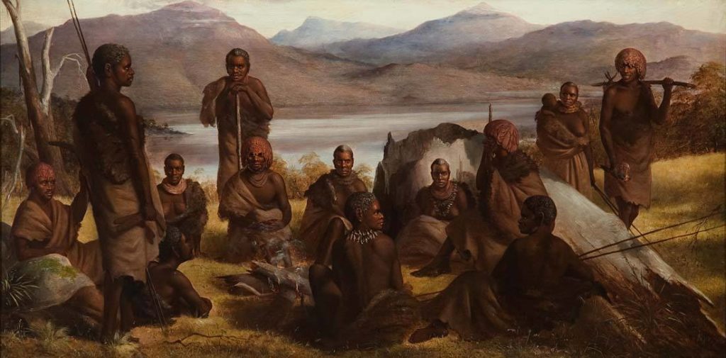
On the west coast, wind batters the dunes above long-used coastal gathering places. Inland, dark rainforest grows in the shelter of steep mountains. To the east, the sea turns turquoise around granite headlands and shellfish grounds. The island south of Terra Australis is neither an empty wilderness nor a mainland province: it is home to peoples who know the seasons, coastlines and high country.
Across the strait, charter pilots from the northern seas increasingly call the island Van Diemen’s Land, a name found on their own maps rather than one accepted by its peoples. In 1454 the island belongs first to the many palawa communities whose countries, relationships and knowledge of seasons long predate foreign landfalls. A handful of guarded foreign harbours and timber stations occupy particular coastal sites; they do not govern the whole island. Their contested presence changes journeys and trade, not the standing of the people already here.
At a Glance
| Land | Large island south of the Australian mainland, separated by Bass Strait, with offshore islands, mountain plateaus, rainforests, grasslands and coasts |
|---|---|
| Inhabitants | Distinct palawa communities with their own countries and histories; limited foreign charter harbours and penal work sites along particular coasts |
| Travel | Established coastal and inland routes, river crossings and sea passages; wind and changing conditions govern access |
| Supplies | Food, water, waterproof shelter, coastal boats and expert knowledge of season, country and crossings |
| Wildlife | Thylacines, wallabies, wombats, seabirds, marine life and other animals suited to different island habitats |
| Campaign pressure | Dangerous coastal weather, river floods, fragile routes, predators and visitors who mistake cultivated cultural landscapes for empty country |
What Is Happening Right Now?
The coast after the storm
Huge surf has broken through the dunes and stranded a small boat at the edge of a fishing place. A visiting party can carry the vessel inland, find sound timber for a repair, or help the fishers move supplies before the next tide. One route across the beach passes a well-used shell midden whose history matters to local people. The choice is how to do the work without damaging the place, not whether to pillage a supposed ancient ruin.
The stripes beyond the grass
Travellers camp at the edge of woodland where a thylacine has been seen near a nesting ground. It is a living animal in the earlier campaign period, not a supernatural ghost or a modern extinction mystery. A frightened visitor wants to kill it; a more experienced hunter knows that a quiet change of route is safer for the camp and animal alike. If the party chooses to approach, their actions can either stop or start a needless fight.
The mountain pass closes
Cold rain turns a steep western foot track into a torrent. A traveller with an injured leg cannot descend before night, and carrying them through the water risks losing everyone. Local knowledge of a sheltered route and a suitable temporary camp matters more than brute force. The party can seek help, construct a crossing or wait out the flood, knowing the delay may affect people expecting the traveller on the coast.
A Different Island in Every Direction
The western and southwestern rainforest
Deep valleys, wet forest, tannin-dark rivers, mountains and gorges create long and demanding journeys. Country that looks impenetrable to an outsider has long histories of Aboriginal presence, with archaeological evidence from caves and shelters and landscapes shaped by targeted burning. The wilderness is not evidence that no people lived there. The western waterways are magnificent, but storms and swollen creeks can defeat a heavy travelling party.
Northwest dunes and shorelines
Coastal camps and productive shellfish places connect families to the sea. The present-day Arthur-Pieman landscape preserves evidence of shell middens, hut depressions and other cultural places associated with the North West nation and distinct clans. These are not anonymous fantasy burial mounds. A journey here is about sea conditions, seasonal food, connections between people and careful travel along wind-blown shores.
Eastern granite coasts
Where rock meets the surf, hidden coves can provide temporary refuge, but an offshore wind makes a boat journey dangerous. Families use coastal resources with skill accumulated over generations. A party trying to move along this coast should learn where the next freshwater stream, shelter and safe landing lie, not simply look for a conveniently placed town.
Central highlands and inland rivers
Cold plateaus, rocky ranges, lakes and rivers differ from the milder coast. Ground can turn treacherous in mist or cold weather. On a longer journey, heat and exposure can both be problems in different seasons. The safest route follows experience: a sheltered crossing, a known ridge or a person who understands where water collects.
People, Skills and Practical Help
Communities on the island do not form one court with one king, capital or official language. A traveller should ask whose country they are approaching and what relationships make a visit possible. Along the coast, help might mean a safe landing, cooked food, materials for shelter and knowledge of weather; inland it might mean a route around a flooded gorge or help carrying an injured companion.
At Windbreak Shore Camp near a northwestern inlet, a skilled boat-mender is protecting the community’s stores of fibre and tools after a storm. Visitors who offer practical labour may be granted safe shelter, but nobody may remove the fishing gear or timber without its owners’ agreement. A charter supply boat has recently anchored nearby, and its master believes the landing is his by right. He is wrong, and the people here are deciding how to make him understand it.
Wildlife, Stories and Sacred Country
The thylacine is a particularly distinctive real inhabitant of this island in the earlier period. Its survival should affect how animals and travellers move around open woodland and wetlands, without making every encounter a monster hunt. Other living traditions are local, bound to places and people, and cannot be collapsed into a single island pantheon. Some important rock marking and cultural sites deserve respectful mention without manufacturing named supernatural guardians or borrowing sensitive stories.
Spirits, fey travellers and creatures from the old sea routes may cross the island, yet the rivers, camps and sacred places remain distinct. A stranger claiming to act for a god must answer to those whose country he enters; no single divine title gives him dominion over every shore. Travellers who mistake a living tradition for permission to steal an object or trespass upon a place may find themselves opposed by its human guardians long before any spirit appears.
Charter Harbours and the Penal Coast
The first foreign merchant landings along the south coast are generations old by 1454. A harbour at Hobart Town serves small charter vessels, while Port Arthur, established as a timber station around 1405, holds convicts under a provost marshal. The English-descended settlements are divided by trade privileges and rival patrons, and none commands the entire island. An armed warrant may be obeyed within a charter wall and rejected the moment a sheriff tries to carry it across another people’s Country.
These footholds bring grievous conflicts as well as new goods: seizure of timber, forced labour, punitive raids, stolen water, disputed landings and the dangerous spread of firearms from distant gnome workshops. Local communities negotiate, resist, trade and protect their routes according to their own decisions; they are never a single frontier faction. A travelling party must discover who has actually granted landing rights before trusting any seal impressed on a captain’s charter.
The Macquarie Harbour records. A ledger from an earlier penal outpost describes the escapes of Alexander Pearce in 1397 and 1398 and his execution in 1399. A charter patron wants the names of the other survivors suppressed before the descendants of an implicated gaoler arrive to claim land. Pearce never served at Port Arthur, which was founded later. The unfinished case is followed among the Oceania characters, but no individual profile has yet been published.
Travel Beyond the Island
Bass Strait divides the island from the mainland and grows dangerous in strong winds. A northern passage leads to Terra Australis; the wider Oceania sea roads connect merchant ports, reef passages and island chiefdoms. Charter vessels use Port Arthur for guarded supplies, but visiting its gaol requires a signed writ, a bribe or an invitation that may be more dangerous than refusal.
Sources and Setting Notes
- UNESCO — Tasmanian Wilderness: deep occupation history, rock shelters and changing managed landscapes.
- Tasmania Parks — Arthur-Pieman: named northwest clans and living coastal cultural landscapes.
- Tasmania Parks — Tasmanian Tiger: thylacine distribution, life and later extinction.
- Tasmania Parks — Port Arthur historical development: opening of the penal station in 1830.
Historical note: British settlement of Tasmania began in 1803 in real-world history, and the historical Port Arthur prison operated from 1830 to 1877. In this world, foreign maritime contact and the charter settlements have much earlier dates. Windbreak Shore Camp and its inhabitants are original campaign material, not documented historical places or people.
Keep this reference growing
If this page helped with your reading or game, you can support its upkeep or explore the curated books.
Explore the Bookshop — epics, classics and stories behind imagined worlds.