
Amazon Rainforest
At a Glance
| Landscape | Andean headwaters, major rivers, floodplains, blackwater forests, uplands, gardens and inhabited forest settlements |
|---|---|
| Travel | Canoes, skilled pilots and known landing places on water; portages and local forest tracks on land |
| Inhabitants | Many distinct communities with their own languages, settlements, alliances, histories and knowledge of particular waterways |
| Supplies | Food, fishing gear, shelter, boat repair, river guides, fibres, cordage and medicinal expertise through local hosts |
| Threats | Floods, submerged wood, illness, unfamiliar channels, territorial beasts and the consequences of ignoring local people |
| What is happening | Families cut off by rising water, a Mapinguari near cultivated ground and a damaged causeway between southern settlements |
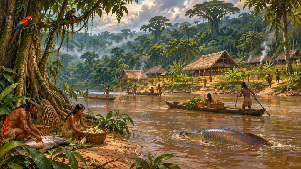
A long canoe slips between trees with water lapping at their lower branches. Fishers have marked a safe channel with stakes. Far beyond the bank, raised paths reach cultivated ground and villages whose people have known these routes for generations. Then something enormous calls from the forest, and the boat’s pilot refuses to land.
From the eastern Andes to the lowland floodplains, rivers carry trade, news and travellers between forests that look alike only to strangers. Every bend has a name, a history and people who know where to land. Water rises among the tree trunks after heavy rains; a canoe that passed easily in the dry season may find its old channel blocked by floating timber. The right pilot knows which bank holds firm ground, which household can shelter visitors and where another community’s fishing grounds begin. On land, dense growth and sodden tracks make the forest harder to cross than the river.
What Is Happening Right Now?
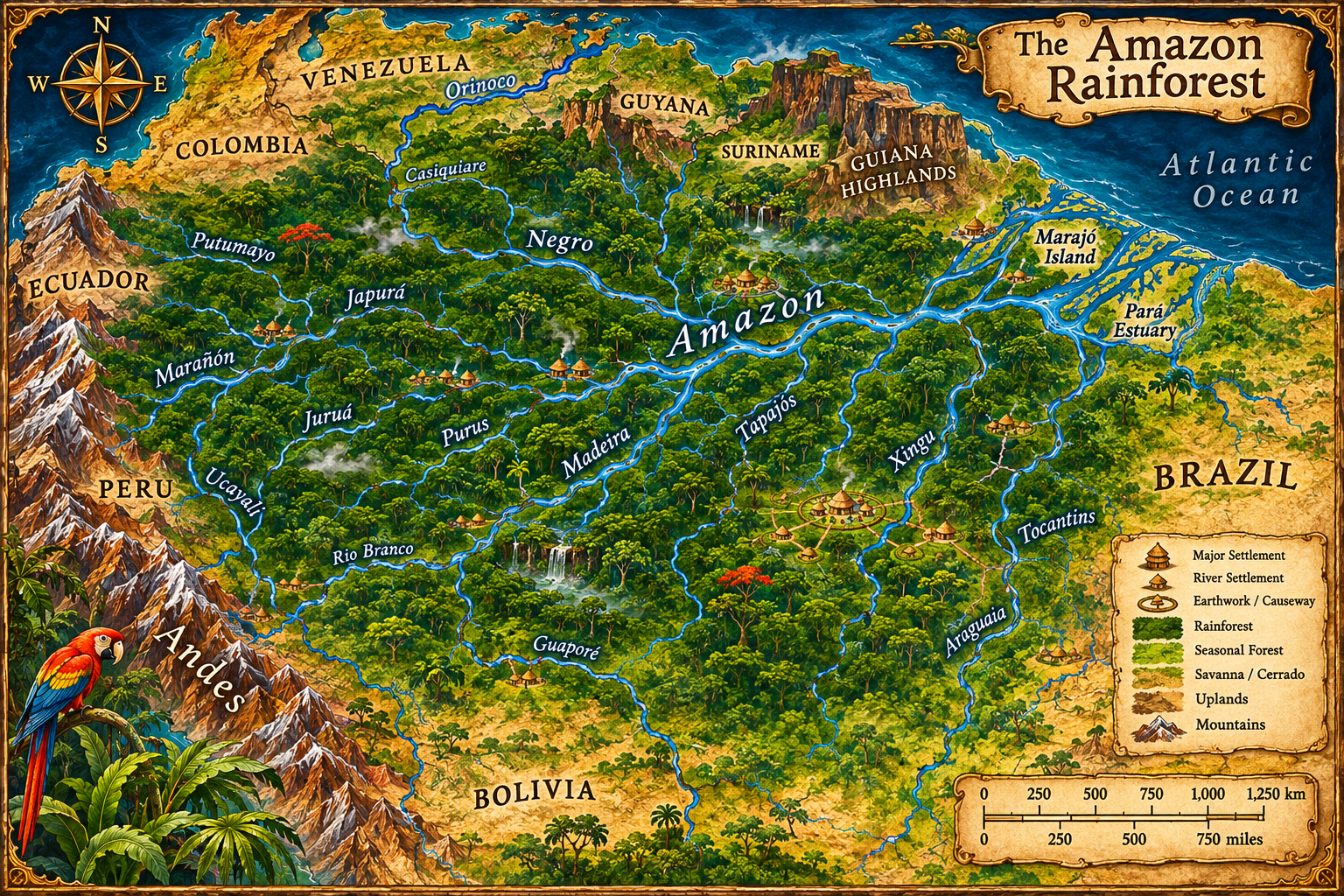
The stranded canoes — Madeira tributary
Rising water has cut off a family returning from upland gardens. Their canoe is tied beyond a submerged landing; a boatwright at nearby Three Canoes Landing can navigate an alternative channel but will not abandon the stranded households to escort paying strangers. The party can help move people and supplies, mend the village’s damaged craft or travel on without the safest pilot. The water rises further with each day of rain.
The howl on the far bank — southwestern forest
A Mapinguari has taken to a patch of high forest near the gardens. Experienced hunters recognise the sound and know that the creature cannot cross broad, deep water. They want the harvest route made safe without driving the beast toward another inhabited bank. Characters can follow its spoor, organise a safer crossing, recover crops from threatened ground or confront the animal on its own territory.
The causeway between the plazas — Upper Xingu
Two neighbouring settlements depend on a raised road linking their plazas. Rain has undermined a crossing just before a meeting and exchange of produce. One community offers timber and labour; another has the boats needed for a detour but is reluctant to surrender its transport. Visitors who understand the routes can help organise repairs or win a negotiated passage. Beyond the crossing, the raised road leads to a broad village plaza where visiting families expect to exchange food, timber and news before the waters rise again.
Four Journeys Through Amazonia
Andean headwaters and the Upano Valley
Eastern Andean valleys send rivers down towards the forest basin. Slopes, rain and sudden changes in river level complicate carrying loads, yet cultivable ground and established routes support long histories of settlement. The Upano Valley has ancient platforms, roads and fields whose builders lived many centuries before the present age. Forest has reclaimed much of their network; travellers may find an old raised way crossing between deserted plazas, but its former cities no longer stand populated as they did in their heyday.
Várzea — the fertile flooded forests
Along sediment-rich white-water rivers, forests and cultivated banks flood for part of the year. A landing used in the dry season may disappear into brown water during the rains. People who live with the river know where to store supplies, when to fish, and which higher ground can shelter boats. For adventurers the obstacle is often not a monster but getting food, fire and injured companions across an inundated reach.
Igapó — blackwater tributaries
Flooded forest along many dark, nutrient-poor rivers has its own trees and ecology. The Rio Negro’s winding tributaries can look deceptively quiet even as submerged trunks, narrow channels and unfamiliar currents make a crossing difficult. Knowledge gained on fertile floodplain rivers cannot simply be transferred to these waterways.
Southern forest towns and the Upper Xingu
South of the main Amazon, evidence of extensive earthworks, planned plazas, raised roads and managed woodland challenges the idea that continuous forest was always sparsely populated. In the period around the campaign’s starting point, substantial settlements and regional networks are appropriate to the Upper Xingu. These are inhabited cultural landscapes, not empty ruins conveniently waiting for treasure hunters. Farmers, fishers, makers and neighbouring communities have their own priorities and obligations to each other.
People, Shelter and Supplies
There is no standard inn or chain of shops stretching across the basin. Along established routes, a party may negotiate food, space under a roof, a sleeping platform or the use of a canoe through local households and their hosts. Food reserves, labour and watercraft have limits; strangers may need introductions or useful work before being welcomed. A village with exceptional boats may have no smith able to repair an imported suit of armour.
Three Canoes Landing is a fictional campaign waystation on a secondary Madeira tributary, set where two channels divide around a wooded island. Nema, a boatwright created for the campaign, repairs paddles and lashings, knows the higher bank and can identify a flood-safe overnight stop. She will not lend her only sound canoe while neighbouring families remain trapped. Another resident knows a vanished low-water route and needs help checking the new channel. The characters can earn assistance through repair work, shared stores or an agreed return trip rather than buying every favour with a fixed price.
Nema keeps an awning over her repair platform and a dry rack for spare paddles. A family shelter on the high bank has water, cooked fish and room for exhausted visitors, but no stock of imported weapons or armour. A plantwise elder can tend cuts and fevers, while specialist metalwork requires travel to an established trading settlement. Skilled guests who mend cordage, carry the sick or join the flood rescue find warmer welcomes than those who merely offer foreign coin.
Living Beings of Forest and River
In the high forest beyond the southwestern tributaries, the great Mapinguari drives hunters from familiar clearings. Its howl leaves the strongest trackers shaking; its enormous claws rip bark high above a man’s head. The creature cannot swim or cross broad, deep water. Villages on the opposite bank can still hear it at dusk, but households seeking crops from its side must risk the narrow forest paths or organise a safer canoe crossing.
The strange Boto Ocota-de-Rosa swims in the flooded channels and casts misleading sights across the water. Boatmen who know its favoured pools watch the surface carefully, for a familiar landing may appear farther away than it is. Great arapaima rise with a hollow gulp beside quiet banks, and jaguars hunt the forest edges. The peril of such places is often discovered by noticing small signs before the river suddenly turns dangerous.
A family travelling from the Negro’s dark tributaries may know different ceremonies, sacred places and accounts of river beings from a host among the southern forest towns. An introduction made in one village does not carry authority into every other. Travellers who listen carefully learn which waters are avoided, which groves are tended and which promises their hosts are unwilling to break.
A Passage Through Rising Water
At Three Canoes Landing, the next day’s departure begins before dawn. Nema examines the lashings on every canoe, marks the flood height on a tree and asks who can carry the spare paddles. A guide will take visitors past the submerged landing to a higher bank, but the detour passes beneath overhanging branches where a wounded passenger must lie still. The company needs food, a sound boat and a destination where their hosts can introduce them to another pilot.
When the river rises quickly, two routes close at once: a shallow ford disappears beneath dark water, while a high island becomes the only place to sleep without standing knee-deep in mud. A scout who reads the current, a craftsperson who repairs a split canoe, a healer who tends an exhausted child and a visitor who earns the pilot’s trust can save the same journey. Steel cannot make the river fall, and gold cannot replace a boat already promised to stranded neighbours.
Rivers and Onward Routes
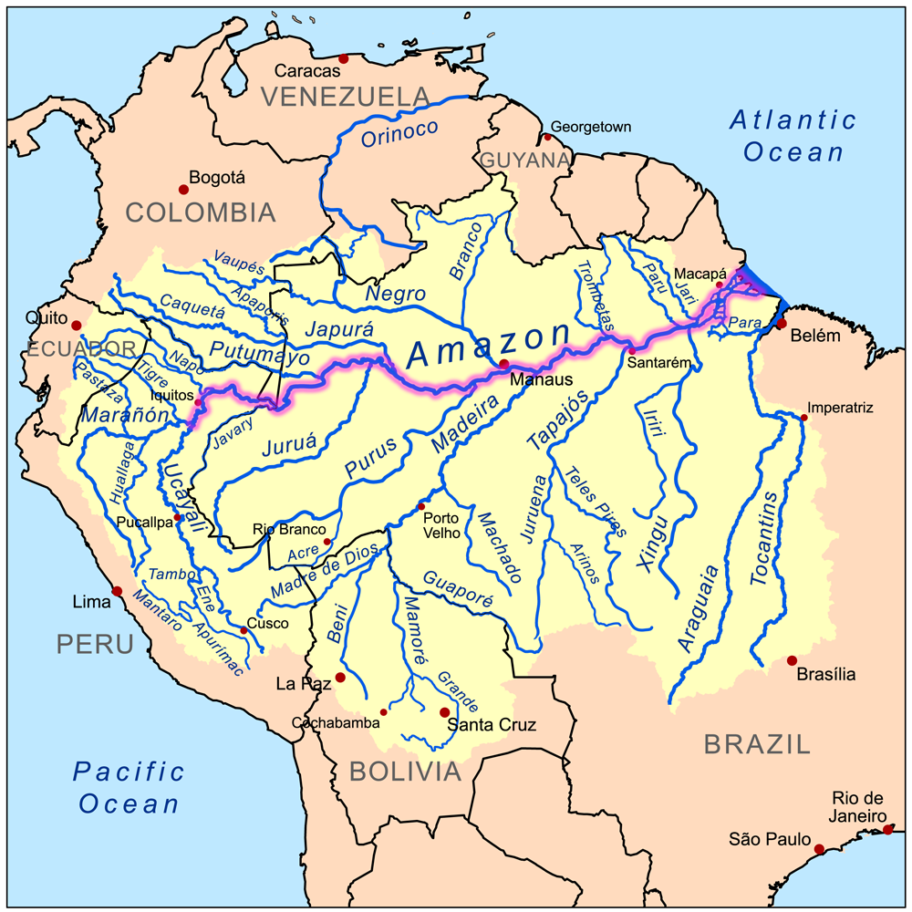
The upper tributaries rise towards the Andes. The Solimões–Amazon joins distant river settlements; the Negro approaches from the north; the Madeira connects southwestern country; the Xingu and Tapajós reach the great river from the south. These waterways are corridors for travel, but reachability depends on seasonal floods, currents, boats and the knowledge of the people who navigate them. An interlinked river basin is not the same thing as a single state or a road across a map.
Travellers leaving the southwestern Madeira headwaters can follow downstream channels towards the main Amazon, but must secure a new pilot where the waters join. To the south, the Xingu and Tapajós lead through distinct settled country with their own ports, gardens and crossing places; towards the west, river travel approaches the Andean foothills where steep land and portages replace the long canoe route. Follow the wider South America and Brazil entries for neighbouring regions, the South American Bestiary for creatures found along the journey, or the World Atlas for other destinations.
Historical and Folklore Sources
- Heckenberger et al., pre-Columbian Upper Xingu urbanism (Science, 2008).
- De Souza et al., pre-Columbian earth builders along the southern Amazon (Nature Communications, 2018).
- CNRS, earlier Upano Valley urban landscapes (2024).
- Wittmann et al., differences between Amazonian flooded forests (Water, 2022).
- Vander Velden, Mapinguari in southwestern Amazonia and Karitiana accounts (2016).
Three Canoes Landing and Nema are named places and people of this setting. The later historical engraving below is retained as an archival illustration, not a contemporary view.

The painted river-village hero is an original fantasy illustration.
Keep this reference growing
If this page helped with your reading or game, you can support its upkeep or explore the curated books.
Explore the Bookshop — epics, classics and stories behind imagined worlds.