
Swabia · Holy Roman Empire · 1454
Baar Wilderness
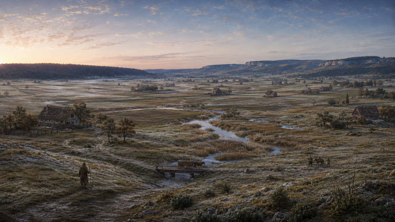
The Baar is a cold, open high country between the Black Forest and the Swabian Alb, where young rivers, old roads, market settlements and farmed uplands cross a patchwork of Fürstenberg rights, Austrian possessions, lesser lordships and local jurisdictions. Marshes and moors occupy its wet depressions, but most of the region is inhabited country; what makes it wilderness is how quickly dependable authority thins between the places where power is strongest.
At a Glance
- Realm
- Holy Roman Empire
- Historic Region
- Swabia; the Baar
- Landscape
- Cold, open high plateau with wet depressions, meadows, fields, forest margins and low ridges
- Elevation
- Around 700 metres across much of the central plateau
- Major Waters
- Brigach, Breg, young Danube and upper Neckar headwaters
- Authority
- Fragmented and overlapping
- Principal Powers
- Fürstenberg, Habsburg Austria, lesser noble houses and self-governing towns
- Languages
- Alemannic regional speech; learned Latin among trained clerks, scholars and magi
Wilderness does not mean empty. The Baar is an old-settled cultural landscape of farms, villages, roads, mills and fortified places. Its wildness lies in marsh, forest, winter, distance and divided authority rather than the absence of people.
The Land
The Baar is a broad upland basin rather than a mountain valley. Much of its central country is open and gently rolling, with long views across cultivated strips, hay meadows, pasture and shallow river valleys. The terrain changes gradually toward darker forest in the west and more pronounced ridges toward the east.
The Open Baar
Open ground forms the region’s everyday landscape. Fields, meadow and pasture spread between villages and isolated farmsteads, broken by hedges, drainage channels, copses and old boundary markers. On a clear day a traveller can often orient by distant hills, woodland edges or settlement towers long before reaching them.
River Country
The Brigach and Breg cross the southern Baar and unite around Donaueschingen to form the young Danube. Smaller streams move slowly through broad valley floors, feeding mills and meadows while turning difficult after prolonged rain or spring thaw.
Ried, Moor and Wet Hollows
The old description of the Baar as a single cold swamp mistakes one part for the whole. Waterlogged ground is real and important: reed beds, peaty hollows, marsh meadow, floodplain and mist-prone depressions can interrupt apparently easy country. Locals know which crossings hold a cart and which become treacherous after only a few wet days.
The Black Forest Margin
Westward, the open plateau rises into the Black Forest. Fields give way to denser woodland, steeper tracks and the working landscape of foresters, hunters, timber cutters and charcoal burners. The forest is a barrier only to those who do not know its routes; old roads connect the Baar with Breisgau and the Upper Rhine beyond.
The Baar Heights
Eastward, low scarps and wooded ridges announce the approach to the Baaralb and Swabian Alb. These heights provide lookout points, quarry stone, defensible ground and routes toward the upper Danube country. They are not alpine mountains, but they are enough to change weather, visibility and travel.
Where Rivers Begin
Water defines the Baar more profoundly than its modest rivers suggest. The Brigach and Breg belong to the Danube system, while the upper Neckar rises in the northern Baar and ultimately runs toward the Rhine. Rain falling only a short distance apart can therefore begin journeys toward entirely different seas.
This watershed shapes mundane life first. Mills need dependable flow. Meadows depend upon drainage and seasonal flooding. Bridges, fords and rights to divert water are valuable. A blocked channel can injure one village while enriching another, and a mill race can become the centre of a lawsuit, feud or act of sabotage.
It also shapes local magic. Boundary-workers, water-diviners and learned natural philosophers pay close attention to springs and divides, while older rites distinguish between waters that flow toward the Danube and those destined for the Rhine. These are regional magical practices and traditions, not a universal law binding every river in the world.
Powers of the Baar in 1454
No single ruler possesses the Baar as a compact state. The Counts of Fürstenberg hold the historic landgravial dignity of the Baar and important territories within it, but the political landscape is broken by Austrian holdings, pledged estates, lesser lordships and towns with rights of their own.
King Rudolf granted Heinrich of Fürstenberg the Landgraviate of the Baar in 1283. Fürstenberg Castle and the small town beneath it became the symbolic centre of that claim, yet the family’s territorial base remained comparatively narrow through the fourteenth and fifteenth centuries. Villingen, the region’s more important economic centre, had passed from Fürstenberg to the Habsburgs in 1326.
In 1454 this is Swabia within the Empire. The later Swabian Circle is not yet an institution; the Imperial Circle system belongs to the reforms around 1500 and afterward.
| Place or Power | Position in 1454 | Regional Importance |
|---|---|---|
| Fürstenberg | Castle, town and principal centre of the Fürstenberg landgravial claim | The strongest symbolic focus of the Landgraviate of the Baar, but not the capital of a neat modern-style territory |
| Villingen | Habsburg Austrian possession since 1326 | A major urban and economic counterweight to Fürstenberg influence |
| Bräunlingen | Austrian, but placed in the pledge and protection of Count Heinrich of Fürstenberg in 1444 with Duke Sigmund’s consent | A clear example of political authority and practical possession overlapping rather than matching neatly |
| Hüfingen | Held by the Schellenberg family; its blood-ban was taken as a Fürstenberg fief after the settlement of 1418 | A lesser lordship whose local authority coexists with Fürstenberg judicial claims |
| Geisingen | Fürstenberg territory since 1318; fortified by the early fifteenth century | An eastern town controlling movement toward the upper Danube corridor |
| Donaueschingen | Not yet Fürstenberg; mid-fifteenth-century possession remains in the Blumberg-Stein succession, with Ritter Sigmund von Stein documented before 1465 | A strategically placed village and castle near the Brigach-Breg confluence; Fürstenberg will not purchase it until 1488 |
| Warenburg | An Austrian lordship pledged to the von Ringingen family in 1441 | A fortified position south of Villingen whose surrounding rights reach into several villages |
| Rottweil | Free Imperial City north of the Baar | An independent urban power, market and political neighbour with interests in the surrounding countryside |
A bridge can stand on one lord’s land, serve a road claimed by another authority, collect a toll pledged to a third family and be maintained by villagers who insist that custom outranks all three. The Baar’s politics become most visible where rights overlap.
Settlements, Castles and Strongholds
Villingen is the region’s most important urban centre, but the Baar does not revolve around one city. Fürstenberg, Bräunlingen, Hüfingen, Geisingen and Donaueschingen anchor different parts of the plateau, while numerous villages, farmsteads, mills and small fortified sites fill the country between them.
Fürstenberg Castle dominates both physically and politically from its height above the southern Baar. Geisingen controls an important eastern approach. Hüfingen combines a compact fortified town with Schellenberg lordship. Bräunlingen embodies the uneasy overlap of Austrian sovereignty and Fürstenberg influence. Warenburg represents another common regional pattern: a castle and its associated rights passing through pledge and sale without making the surrounding political map any simpler.
Donaueschingen is still a modest castle settlement rather than the later Fürstenberg princely residence. Treating it as a great Fürstenberg capital in 1454 projects its future backward by more than a century.
Roads and Movement
The Baar is a corridor between larger regions. Westward roads climb through the Black Forest toward Breisgau and the Upper Rhine. Northern routes lead through Villingen toward the upper Neckar and Rottweil. Eastward roads follow the upper Danube country toward the Swabian Alb, while southern movement connects the Baar with Hegau and the approaches to the Upper Rhine.
These roads are older than many of the powers taxing them. Roman routes, earlier trackways and medieval improvements overlap in places, and a road can remain important long after the authority that first maintained it disappears. Inns, ferries, bridges and toll points therefore matter as much politically as many small castles.
Good roads across the open plateau can be fast in dry weather. The same journey becomes very different in autumn fog, spring thaw or winter snow. A cart that leaves the established road for wet meadow can lose more time in an hour than it gained during the preceding half-day.
People and Economy
Most inhabitants live from the land. Arable farming occupies suitable open ground, while hay meadow and grazing are particularly valuable where cold or wet soils make other cultivation uncertain. Cattle, sheep, horses and working animals connect farm economy to the roads, markets and mills.
Woodland supplies construction timber, fuel, charcoal, game and seasonal work. Streams power mills and provide fish, water and transportable energy even when they are too small for serious navigation. Smiths, wheelwrights, tanners, millers, carters, drovers and innkeepers all depend upon traffic between the towns and countryside.
Human communities form the majority of the settled population, but the region is not exclusively human. Dwarven craftsmen, wardens and itinerant families can be found around market towns, metalworking and long-distance trade, while halfling householders, carters and travelling families move through the same rural networks. Neither group requires a separate kingdom to be present in the Baar.
Speech and Learning
Alemannic regional speech dominates much of the Baar, changing from town to town and shading toward neighbouring Swabian forms. There is no universal Common language. A traveller may understand a related dialect imperfectly and still miss legal formulas, insults, place-names or technical vocabulary.
Learned Latin remains important among trained clerks, scholars, jurists and practitioners of formal magic. Arcane learning can pass through schools, courts, university networks, private masters and apprentices, while rural magical practice is more often transmitted through households, craft traditions and local circles. These traditions can disagree over method and authority without being different forms of physics.
Seasons and Weather
Elevation and the shape of the high basin make the Baar colder than many neighbouring lowlands. Cold air settles into hollows, frost can arrive early or linger late, and mist gathers readily above wet ground. The result is a region where weather matters even when it is not extraordinary enough to become an immediate survival hazard.
| Season | Typical Conditions | Regional Effect |
|---|---|---|
| Spring | Thaw, rain, swollen streams and saturated meadow | Fords become uncertain, side roads break up and low ground can remain unusable after higher ground dries |
| Summer | Long working days, open roads, grazing and sudden storms | Trade and agricultural traffic peak, making tolls, markets and road security more important |
| Autumn | Harvest movement, low mist, wet ground and early frost | Visibility can collapse while roads remain busy with carts, livestock and travellers |
| Winter | Repeated frost, snow, frozen tracks and short days | Some wet ground becomes easier while exposed travel, blocked roads and isolated households become greater concerns |
The Mythic Baar
The supernatural Baar follows the real shape of the land. Springs, old roads, forest margins, wetlands, boundary stones and ruined strongholds carry more weight than generic haunted wilderness. A spirit is usually attached to a place, route or customary right rather than wandering the plateau without reason.
Abnoba and the Western Roads
Abnoba is older than the medieval lordships that now divide the region. She was known as a power of the Black Forest and adjoining country long before 1454, and Roman worshippers later identified her with Diana. Archaeological dedications associated with roads, traffic junctions and passes suggest that her ancient sphere extended beyond hunting and woodland into the protection of dangerous movement through the forest.
In the campaign, Abnoba remains real. Her oldest places are rarely grand temples. A weathered stone beside a pass, an old hunting ground, a spring under firs or a road where travellers leave offerings may matter more than a formal shrine. Her favour is local and personal; she does not govern every forest in Europe.
Old Roads and Boundaries
Roads remember previous masters. Boundary stones can outlast the charters that explain them, and some stand on lines older than the current lordships. Local witches, surveyors and magi sometimes exploit these accumulated claims when laying wards or settling disputes, but moving an old stone can disturb more than a legal boundary.
Waters That Remember
Springs and millponds accumulate stories because the same water is used, crossed and bargained over for generations. A drowned ford may acquire a resident spirit; a mill pool can become territorial; an old source can retain obligations forgotten by the village that depends upon it.
Regional Folklore
Later collections preserve a rich body of stories explicitly associated with the Baar. They are valuable evidence for regional tradition, but a tale first printed in the nineteenth century is not presented as a surviving written record from 1454. In the mythic campaign, the beings behind some of those later stories can nevertheless already be real.
The Kolmen-Weibchen
One later-recorded Baar tradition describes the Kolmen-Weibchen, a small mountain woman associated with lonely high ground and travellers who lose their way. In 1454, stories of a woman of the heights circulate unevenly among foresters, herders and people using the western routes. Those who anger her can walk a familiar road for hours only to return to the same tree, cairn or boundary stone.
The Kolmen-Weibchen does not need to be a routine combatant. She may misdirect trespassers, punish oath-breakers, guard a place, demand restitution or lead a respectful traveller through weather that defeats everyone else.
Wild Lights
Villingen and the surrounding country preserve later stories of strange fire, and the Baar’s real marshes offer plenty of places for dangerous lights to appear. Locals do not assume every wandering flame has the same cause. Some are natural marsh lights, some are spirits, and some are predatory Will-o’-Wisps deliberately leading travellers toward bad ground.
Wildlife and Supernatural Ecology
Most things encountered in the Baar are ordinary. Deer browse woodland edges, wild boar root in cover, wolves move through less settled country, foxes hunt the field margins and waterfowl gather in wet depressions. Livestock, farm dogs, horses, carts and people are more common on good roads than monsters.
Supernatural creatures tend to occupy particular niches. A Will-o’-Wisp favours marsh, old death-sites and places where false light can exploit dangerous terrain. A Wassernixe may claim a millpond, ford, slow river bend or deep channel, turning one piece of water into a local danger remembered for generations.
A Nymph belongs at an exceptional spring, grove, meadow or river-place rather than appearing as common fauna. Such a being can be more powerful than nearby political authorities precisely because her power is tied to one place rather than a territory drawn on a lord’s map.
Ancient powers such as Abnoba sit above ordinary encounter ecology. They are regional presences with memory, followers, enemies and places of influence, not random inhabitants selected because travellers have reached a particular level.
Travel in the Baar
The Baar is usually straightforward country when travellers remain on known roads in fair weather. Difficulty comes from choosing the wrong kind of ground at the wrong time: saturated ried, fog, forest navigation, broken bridges, snow, flooded fords or a shortcut across country that is much slower than it appears.
5.5e / 2024 Travel
Break a long journey into stages and use the predominant terrain for each stage. Open cultivated Baar generally behaves as grassland; the forest margin as forest; the eastern heights as hill; and only genuinely saturated ried or marsh should use swamp.
| Baar Terrain | Rules Terrain | Maximum Pace | Foraging DC | Navigation DC | Search DC |
|---|---|---|---|---|---|
| Open fields, meadow and pasture | Grassland | Fast | 15 | 5 | 15 |
| Black Forest margin | Forest | Normal | 10 | 15 | 15 |
| Baar heights and ridges | Hill | Normal | 15 | 10 | 15 |
| Saturated ried, deep reed-bed or true marsh | Swamp | Slow | 10 | 15 | 20 |
A good road raises the terrain’s maximum pace by one step, from Slow to Normal or from Normal to Fast. At a Fast pace, travellers have Disadvantage on Wisdom (Perception or Survival) checks and Dexterity (Stealth) checks. At a Normal pace, travellers have Disadvantage on Dexterity (Stealth) checks. At a Slow pace, travellers have Advantage on Wisdom (Perception or Survival) checks.
Long days: after 8 hours of travel, each additional hour requires the normal Constitution save for extended travel: DC 10 plus 1 for each hour beyond 8. Failure gives 1 Exhaustion level.
Morning frost, ordinary rain and typical winter cold do not automatically impose an environmental hazard. Use the system’s cold, precipitation and visibility hazards only when conditions are severe enough to meet those rules. A misty Baar morning should change what travellers can see before it starts injuring them.
Pathfinder 1e Travel
Use the Pathfinder overland terrain multipliers rather than treating the whole Baar as swamp. Roads make the open plateau efficient; trackless forest, hill and saturated wetland are much slower.
| Baar Terrain | Road or Trail | Trackless | Typical Navigation |
|---|---|---|---|
| Open plateau | ×1 | ×3/4 | Plains; Survival DC 14 when a navigation check is actually required |
| Moor and open wet meadow | ×1 | ×3/4 | Moor or hill; Survival DC 10 |
| Black Forest margin | ×1 | ×1/2 | Forest; Survival DC 16 |
| Baar heights | ×3/4 | ×1/2 | Moor or hill; Survival DC 10 |
| True swamp or saturated ried | ×3/4 | ×1/2 | Use the nearest matching visibility and terrain circumstances; dense reed or willow cover can function like forest for navigation |
A character following an obvious road, trail, river or other dependable landmark normally does not need to make repeated getting-lost checks merely because the journey crosses the Baar. When navigation matters, proper tools grant the standard +4 bonus and poor visibility imposes the standard –4 penalty.
Local difficult ground: difficult terrain, obstacles and poor visibility can hamper tactical movement. Each hampering condition normally doubles the relevant movement cost, and a creature cannot run or charge through terrain that hampers movement.
Forced marches, exposure, cold and severe weather use the normal Pathfinder environmental rules. The Baar changes how often those circumstances arise; it does not replace the core procedures.
D&D 3.5e Travel
Use the terrain and overland movement multipliers that match the part of the Baar being crossed. Open roads are efficient; trackless hill, forest and swamp reduce distance sharply.
| Baar Terrain | Highway | Road or Trail | Trackless |
|---|---|---|---|
| Open plateau / plains | ×1 | ×1 | ×3/4 |
| Moor | ×1 | ×1 | ×3/4 |
| Forest margin | ×1 | ×1 | ×1/2 |
| Hills and Baar heights | ×1 | ×3/4 | ×1/2 |
| True swamp / saturated ried | ×1 | ×3/4 | ×1/2 |
Where getting lost is possible, moor or hill uses Survival DC 6 with a map and DC 10 without one. Poor visibility uses DC 12, and forest uses DC 15; apply the highest relevant DC. A guide with at least 5 ranks in Knowledge (geography) or relevant Knowledge (local) gains the normal +2 bonus.
Fog and bad ground: difficult terrain and poor visibility each normally double local movement cost. When several hampering conditions apply, their costs can multiply under the 3.5e movement rules.
Forced march, cold exposure and other environmental dangers use the ordinary 3.5e procedures. Do not treat every frost or wet meadow as a hazard simply because the Baar has a cold climate.
Regional Conflicts and Adventure Hooks
Trouble in the Baar usually begins with a place, right or route that matters to more than one person. Monsters can make a dispute worse, but they do not need to be the reason the dispute exists.
| Situation | What Is Happening |
|---|---|
| The Moved Stones | Ancient boundary stones have been shifted during the night. Two lords accuse one another, but villagers insist that moving the stones has disturbed something older than either claim. |
| Two Writs, One Prisoner | An arrest made on disputed ground brings Fürstenberg and Austrian officers to the same village, each carrying a document that appears to give them lawful custody. |
| The Bräunlingen Pledge | A faction inside the town challenges what Fürstenberg’s protection actually allows, while Austrian agents insist that sovereignty was never surrendered. |
| Warenburg’s Old Rights | A forgotten charter connected to Warenburg appears to grant toll, woodland or village rights more extensive than the present holder can safely enforce. |
| The Divided Water | A miller diverts a stream close to the watershed. The practical dispute becomes stranger when old magical markers suggest that the water’s destination matters to a long-standing local pact. |
| The Road That Returns | Travellers using a western track repeatedly arrive back at the same marker. Locals say the woman of the heights has been offended, but nobody agrees by whom. |
| Lights in the Ried | Lantern-like lights appear along a flooded route after dark. Some are harmless marsh fire; at least one is watching travellers and learning which paths they trust. |
| Abnoba’s Road | A road improvement crew removes an ancient carved stone from a forest pass. Hunting fails, animals refuse the crossing and travellers begin vanishing between two milestones. |
The Baar in Later Art
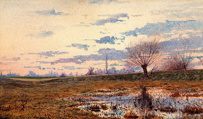
Hermann Dischler’s later painting Die Baar captures one of the landscape’s enduring features: open ground broken by shallow water and a broad horizon. It is not an image of 1454, but it remains a useful artistic view of the region itself.
Related Locations
Sources & Licensing
Bundesamt für Naturschutz — Landschaftssteckbrief: Baar. Regional geography, open high-plateau character, average elevation and wet depressions.
Deutsche Biographie — Fürstenberg. Fürstenberg’s inheritance on the Baar, the 1283 landgravial grant, loss of Villingen to the Habsburgs in 1326 and the family’s narrow fourteenth- and fifteenth-century territorial base.
Landesarchiv Baden-Württemberg / LEO-BW — Bräunlingen charter, 28 April 1444. Bräunlingen’s pledge and protection under Count Heinrich of Fürstenberg with the knowledge and consent of Duke Sigmund of Austria.
LEO-BW Historisches Ortslexikon — Hüfingen. Schellenberg possession and the 1418 settlement under which the blood-ban was held as a Fürstenberg fief.
LEO-BW Historisches Ortslexikon — Donaueschingen. Mid-fifteenth-century lordship, Ritter Sigmund von Stein before 1465 and the later Fürstenberg purchase in 1488.
LEO-BW Historisches Ortslexikon — Geisingen. Transfer to Fürstenberg in 1318 and late-medieval urban fortification.
LEO-BW Historisches Ortslexikon — Warenburg. The castle’s Austrian transfer, associated villages and pledge to von Ringingen in 1441.
Badisches Landesmuseum / LEO-BW — Diana Abnoba. Archaeological evidence for Abnoba as a Black Forest deity and the concentration of dedications near long-distance roads, junctions and passes.
August Schnezler (ed.), Badisches Sagen-Buch, Vol. I, 1846. Later-recorded Baar folklore including the Kolmen-Weibchen and Villingen traditions. These are treated as later evidence for regional folklore rather than contemporary fifteenth-century written testimony.
System Reference Document 5.2.1. Travel pace, terrain, navigation, foraging, search and extended-travel procedures used in the 5.5e / 2024 tab.
Pathfinder Roleplaying Game Core Rulebook / Archives of Nethys. Overland movement, hampered movement and wilderness navigation procedures used in the Pathfinder 1e tab.
Revised d20 System Reference Document. Overland terrain multipliers, getting lost and hampered-movement procedures used in the D&D 3.5e tab.
This page includes adapted material from the System Reference Document 5.2.1 by Wizards of the Coast LLC, used under the Creative Commons Attribution 4.0 International Licence.
Pathfinder First Edition and D&D 3.5e rules material is presented as Open Game Content under the Open Game License v1.0a. Original SpiralWorlds explanations, rulings, comparisons, setting material, artwork and editorial material are not designated as Open Game Content.
Open Game License v1.0a & Copyright Notices
Open Game License Version 1.0a
The complete Open Game License Version 1.0a governing the Open Game Content used on this page is available from the following source:
Open Game License Version 1.0a
Section 15 Copyright Notices
The applicable copyright notices for the Open Game Content used here are contained in the source documents below.
Keep this reference growing
If this page helped with your reading or game, you can support its upkeep or explore the curated books.
Explore the Bookshop — epics, classics and stories behind imagined worlds.